|
Status: |
North Eastern State of India |
|
Shopping: |
- |
|
History of: |
- |
|
Population: |
23 Lac |
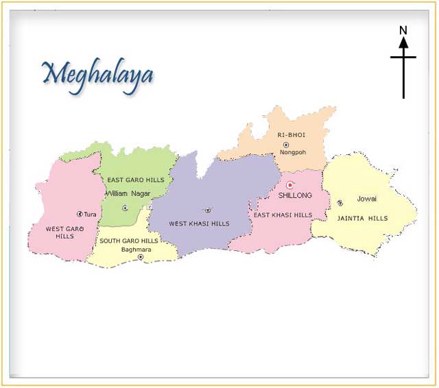
Meghalaya is situated in
the north-eastern region of India, between the Brahmaputra valley in
the north and the Bangladesh in the south. It extends for about 300
kilometres in length and about 100 kilometres in breadth. The state
was created in 1972 from the Khasi, Jaintia, Garo districts of Assam,
which were formerly small kingdoms inhabited by separate tribal
groups. The state of Meghalaya (the abode of clouds) is geographically
known as the "Meghalaya Plateau" or the "Shillong Plateau". The area
is made of the oldest rock-formations. Meghalaya consists of the Garo,
Khasi and Jaintia hills along with their outliers formed by the Assam
ranges. It is the detached north-eastern extension of the Peninsular
India. Part of it lies buried under the alluvium deposited by the
Ganga-Brahmaputra system of rivers. This gap is known as Malda gap
(between Raj Mahal hills/Chhota Nagpur and the Shillong Plateau).
Meghalaya Plateau's elevation varies between 150 meters to 1961 meters
above sea level. The highest point of the entire state is the Shillong
peak whose elevation is about 1965m above sea level. It is bounded on
the south and southwest by Bangladesh and on all other sides by the
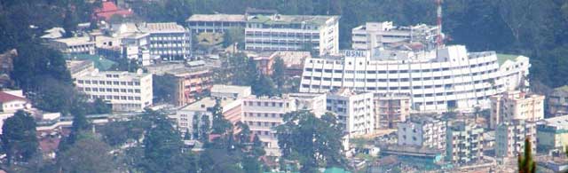
state of Assam. The area is 22,429 square kilometres. The capital is
the hill town of Shillong. Shillong, the capital of Meghalaya is
located at an altitude of 1496 metres above sea level. Shillong, which
was made Assam's capital in 1874, remained so till January 1972,
following the formation of Meghalaya. The capital city derives its
name from the manifestation of the creator called Shyllong. Meghalaya
is a region of great scenic beauty; a panorama of lush, undulating
hills, fertile valleys, 250 species of orchids, meandering rivers,
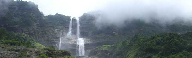
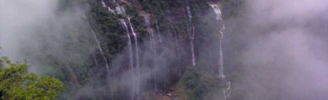
waterfalls, sparkling mountain streams and lakes. Meghalaya is known
for its natural beauty and the simple lifestyle of its tribal people.
Meghalaya also receives limelight on account of Cherrapunjee, the
wettest place on earth, which is only 56 kms. away from Shillong.
Meghalaya has a single-chamber Legislative Assembly of 60 seats.
Flora and Fauna
Meghalaya is endowed with a rich variety of flora and fauna. Of about
17,000 species of orchids in the world, around 3000 varieties are
found in Meghalaya. A botanical wonder, the pitcher plant, an insect
eating plant is found in the district of Jaintia hills, West Khasi
hills and South Garo hills of the state. Animals and birds that are
found in the state are elephants, tigers, bear, jackal, leopard,
golden langurs etc. The interesting birds found in the state include
Hornbills, King Vulture, Crested Serpent, Eagle, Partridges, Teals,
Snipes, Quails etc.
Climate
Meghalaya is subject to vagaries of the monsoon. The climate varies
with altitude. The climate of Khasi and Jaintia Hills is uniquely
pleasant and bracing. It is neither too warm in summer nor too cold in
winter, but over the plains of Garo Hills, the climate is warm and
humid, except in winter. The Meghalayan sky seldom remains free of
clouds literally it is the Abode of the Clouds. The average annual
rainfall is about 2600 mm over western Meghalaya, between 2500 to 3000
mm over northern Meghalaya and about 4000 mm over south-eastern
Meghalaya. There is a great variation of rainfall over central and
southern Meghalaya. At Sohra (Cherrapunji), the average annual
rainfall is as high as 12000 millimetres, but Shillong located at a
distance of about fifty kilometres from Sohra receives an average of
2200 mm of rainfall annually.
Rivers
In the Garo hills, the important rivers of the northern system from
west to east are the Kalu, Ringgi, Chagua, Ajagar, Didram, Krishnai
and Dudnai. Of these only the Krishnai and Kalu are navigable. The
important rivers of the southern system are Daring, Sanda, Bandra,
Bhogai, Dareng and Simsang. Simsang is the largest river in the Garo
hills and navigable only for about 30 Km . Other navigable rivers are
Nitai and the Bhupai. In the central and eastern section of the
plateau the important northward flowing rivers are Umkhri, Digaru and
Umiam and the south-flowing rivers are Kynchiang (Jadukata), Mawpa,
Umiew or Barapani, Myngot and Myntdu.
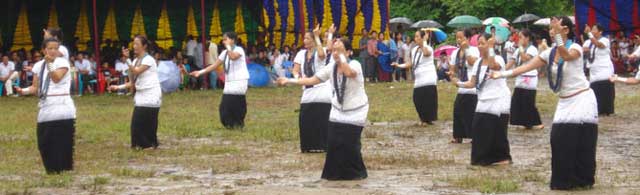
People
The population of the state is unevenly distributed and is determined
by physiographic factors and accessibility. The population of the
state is mainly concentrated in the area around Shillong urban
agglomeration, Jowai, Nongstoin, Williamnagar, Tura and Baghmara, the
neighbourhood of Cherrapunji and Dawki and Northern, western and
southern fringes of the Garo hills. The sparsely populated areas of
the state is found in the northern and southern Khasi hills, most of
the Jaintia hills and the interior of the Garo hills. The population
of the state can be classified into tribal and non-tribal population.
Tribal peoples make up about 85 percent of Meghalaya's population.
Among tribal population, Meghalaya is dominated by three principal
groups of people i.e the Garos in the western section of the plateau,
the Khasis in the central section of the plateau and the Jaintia in
the eastern section of the plateau. All the three have a matrilineal
social system in which the family lineage is taken for the mother's
side. Within the four districts of the combined Khasi and Jaintia
hills there are number of dialects. Based on the dialects, the
community is generally divided into five groups namely the Khasis of
the central plateau, the Pnars or Jaintia in the east, the Wars in the
south, the Lyngams in the west and the Bhois in the north. Most of the
houses are constructed in accordance with the people's tastes. There
is a great variation which ranges from the old Khasi type to the
modern types found in Shillong and other important towns of the state.
In some Jaintia and Garo villages, engravings of the figures of men
and animals are found on the house walls. Near Jowai, the carvings of
a lover and his beloved are seen which evoke acclaim even today for
artistry and ingenuity in designing. The Garo women are expert in
weaving. Dakmandes, a kind of women's wear, are well decorated with
depictions of beautiful flowers and butterflies, in various colour
combines. Baskets, sleeping mats, winnowing fans, rain shields
manufactured out of plaited bamboo and cane are found in the rural
areas. Jaintia fishing traps made of bamboo sticks are also noted for
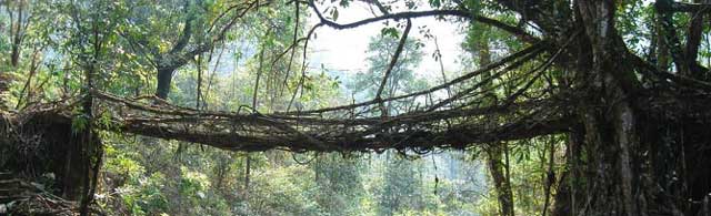
functional beauty. The cane bridges hanging over quick-flowing streams
also testify to the superb craftsmanship of the Khasis and Jaintias.
The non- Christian Garos erect memorials for the dead. Those are
actually statues engraved in wooden posts, in the shape, form and
facial resemblance of the deceased. Meghalaya occupies a total area of
22,429 sq kms with a total population of 2,306,069 persons as reported
in the census of 2001. The sex-ratio in Meghalaya was 974 females per
1000 males; as against 923 females for the country as a whole. The
fairly high sex ratio in Meghalaya may be attributed to the existing
tradition of matrilineal society.
Agriculture
Agriculture is the main occupation of Meghalaya, with eighty three
percent of the total population, dependent on it for their livelihood.
Rice and maize are the major food crops. Important fruits grown here
are orange, pineapple, lemon, guava, jackfruit and bananas, while
potato, jute, mesta, cotton, arecanut, ginger, turmeric, betel leaf
and black pepper are the chief commercial crops. 'Jhum' or the
shifting system of cultivation is being replaced with scientific
methods, bringing land under permanent cultivation. Forest resources
from pine and other timber products bring in the major chunk of state
revenue. The state has many small scale industries in furniture
making, iron and steel fabrication, tyre retreading and baking, to
name the principal ones.
Minerals
Meghalaya has abundant but untapped natural resources, including coal,
limestone, kaolin, feldspar, quartz, mica, gypsum, bauxite, and other
minerals. Its sillimanite deposits (a source of high-grade ceramic
clay) are reputedly the best in the world and account for almost all
of India's sillimanite output. Most of the natural resources are
extracted and sent outside the state only in raw form. Meghalaya has
no heavy industries; small-scale industries include cement, plywood,
and beverage factories, in addition to a newly established electronics
plant.
How to reach there
 |